ITB Geology Expert: West Bandung Landslide Triggered by Interaction of Natural and Human Factors
By Merryta Kusumawati - Teknik Geodesi dan Geomatika, 2025
Editor Muhammad Efriza Pandia
BANDUNG, itb.ac.id - he landslide disaster in West Bandung Regency has drawn national attention amid the increasing frequency of hydrometeorological hazards across Indonesia. The Meteorology, Climatology, and Geophysics Agency (BMKG) has forecast that extreme weather, including heavy rainfall accompanied by thunderstorms and strong winds, may persist until early February 2026, with the possibility of high-intensity rainfall continuing over the following months. These conditions heighten the risk of secondary disasters, particularly in areas with vulnerable geological and geomorphological characteristics.
Extreme Rainfall as a Trigger, Not the Sole Cause
Landslide geology expert from Institut Teknologi Bandung (ITB), Dr.Eng. Imam Achmad Sadisun, S.T., M.T., explained that high-intensity rainfall acts as a trigger for landslides, but it is not the only contributing factor. According to him, landslides result from the interaction of multiple natural factors and human activities on slopes.
“Extreme rainfall often serves as a trigger; however, other factors such as slope steepness, soil and rock types, degree of weathering, land cover, and human activities are equally decisive,” he said.
He further noted that moderate rainfall over a prolonged period can be just as hazardous as very heavy rainfall over a short duration, as both conditions may lead to soil saturation. This explanation was also delivered by Dr. Imam during his appearance as a guest speaker on Metro TV’s Hotroom program, where he emphasized that landslides should be understood as part of long-term geological and environmental processes rather than isolated events.
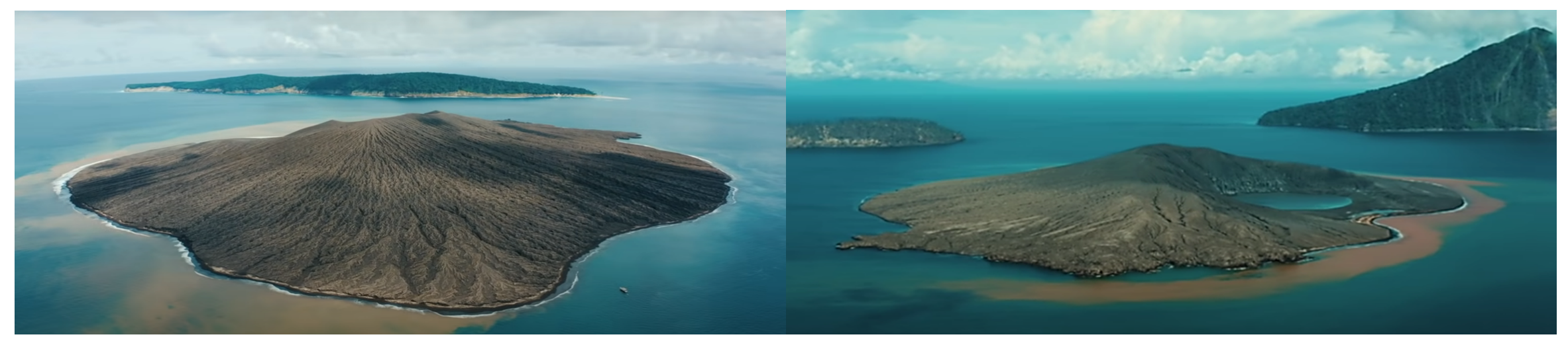
Geological and Geomorphological Conditions of West Bandung
According to Dr. Imam, West Bandung Regency is situated in a geological environment dominated by old volcanic products with relatively thick weathered layers. The boundary between weathered soil and less permeable bedrock often serves as a potential slip surface.
“This condition becomes increasingly weak when rainwater infiltrates and fills soil pores until saturation. At that point, the shear strength of slope materials decreases drastically, and the slope can no longer support its own weight,” he explained.
Geomorphologically, the dominance of hilly and mountainous terrain in West Bandung naturally results in a high susceptibility to landslides, particularly on steep slopes that are directly connected to river systems.
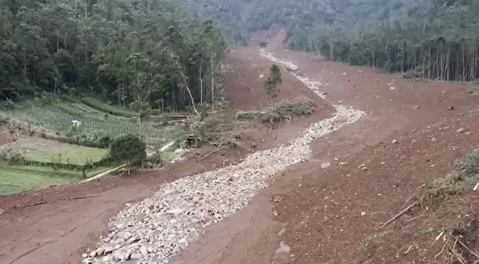
Extensive Impacts and Upstream Material Transport
Based on information from local authorities, the landslide in Pasir Langu Village, Cisarua District, West Bandung Regency, affected a wide area and resulted in significant loss of life. Several days after the incident, search and rescue operations were still ongoing for residents buried by landslide material, while hundreds of others were forced to evacuate for safety reasons.
Dr. Imam explained that severe impacts are not always caused by local slope failures near residential areas. In many cases, damage is triggered by landslide materials originating upstream and transported through river channels.
“Houses are not always located within the source area of landslides, but are impacted by materials delivered from upstream through connected river systems,” he said.
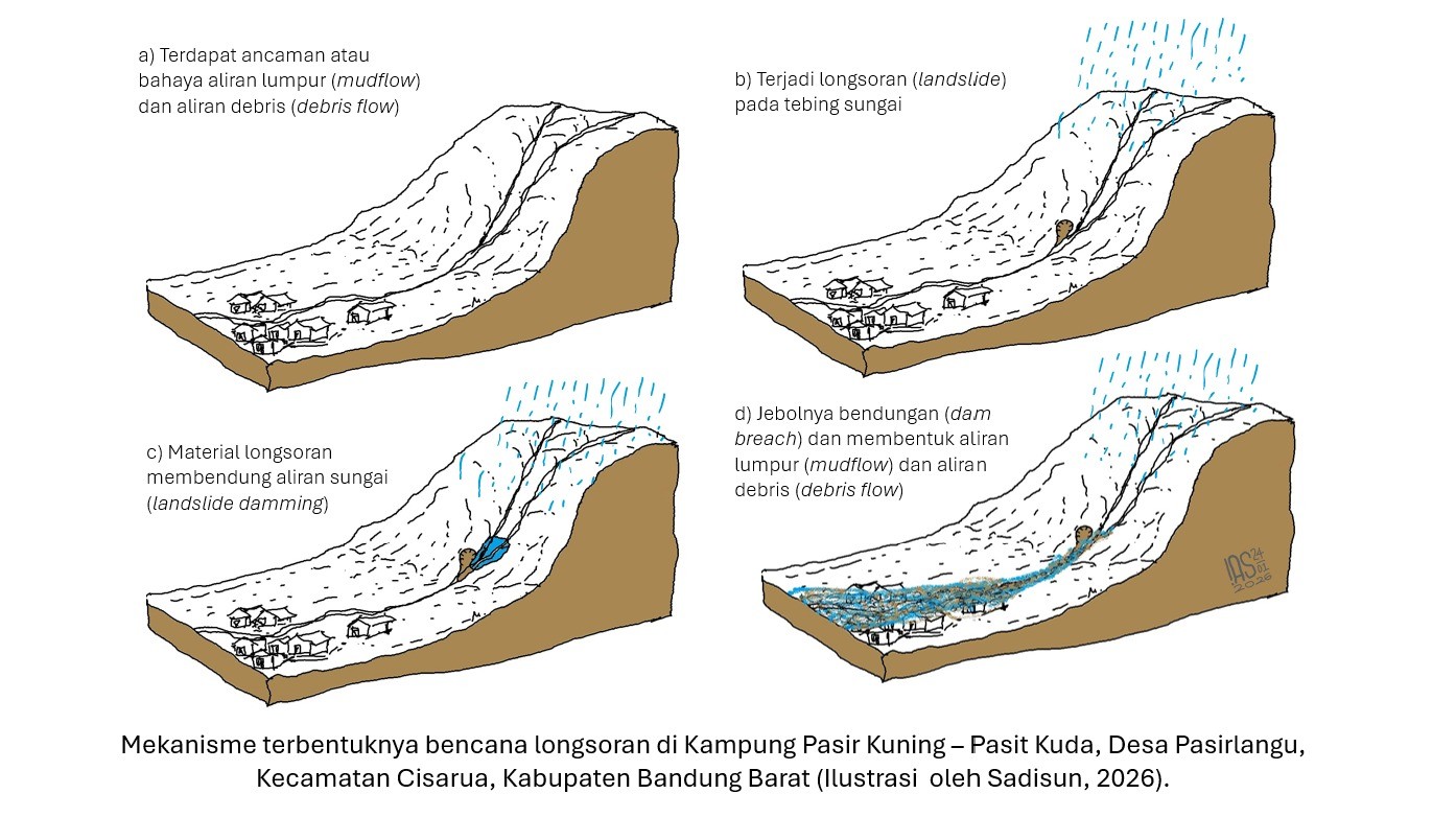
Potential Secondary Hazards Along River Channels
He also warned of potential secondary hazards following the landslide, particularly if material blockages remain in upstream river sections. Such blockages may form temporary natural dams that retain water and sediment.
“If heavy rainfall occurs again, these natural dams may fail and trigger mudflows or debris flows downstream,” Dr. Imam stated.
According to him, sediment-laden flows possess far greater destructive power than ordinary water flow, making areas along riverbanks especially vulnerable and in need of heightened vigilance.
Risks in Areas with Similar Characteristics
Dr. Imam emphasized that landslide hazards are not limited to West Bandung but may also occur in other regions with similar geological and geomorphological characteristics, such as Bogor and several other areas in West Java.
“Each region has distinct landslide characteristics. In some areas, geology plays a dominant role, while in others, slope steepness or land cover changes are more influential. Therefore, mitigation strategies must be tailored to local conditions,” he explained.
Susceptibility Mapping and Science-Based Mitigation
Dr. Imam highlighted that Indonesia already has landslide susceptibility zoning maps accessible to the public and policymakers. These maps provide information on landslide hazard levels and should serve as a primary reference for spatial planning and development activities.
“By understanding regional susceptibility levels, communities can enhance their preparedness, while governments can formulate safer development policies,” he said.
In the long term, he stressed the importance of science-based disaster mitigation through both structural and non-structural measures, including slope stabilization in upstream areas, monitoring of material flow paths, and the enhancement of public disaster literacy. Through the application of scientific information and strengthened environmental and spatial governance, ITB continues to promote more planned and sustainable disaster mitigation efforts to reduce future risks and impacts.
Reporter: Merryta Kusumawati (Geodesy and Geomatics Engineering, 2025)
.jpg)
.jpg)
.jpg)
.jpg)