From Boarding Houses to Triumphs: The Journey of ITB’s RAR.GIS Team Securing 1st Place in the GIS Thematic Competition
By Mely Anggrini - Mahasiswa Meteorologi, 2022
Editor Anggun Nindita
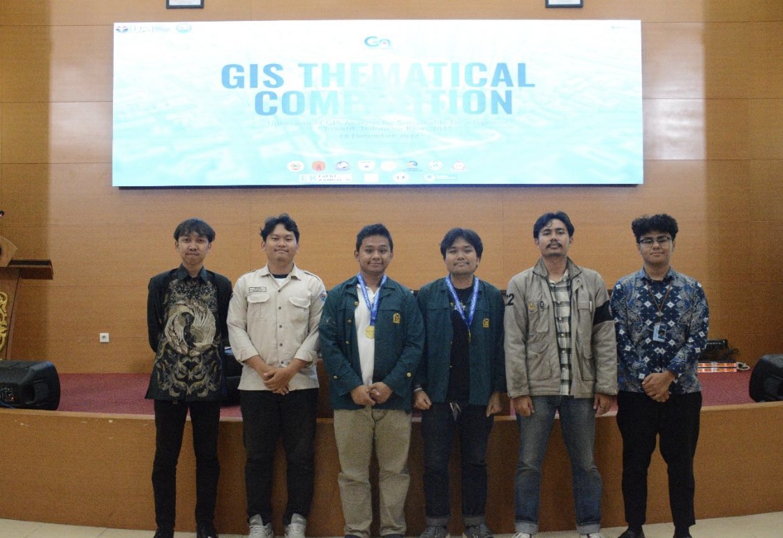
Institut Teknologi Bandung’s RAR.GIS Team Won 1st Place in the GIS Thematic Competition 2024 held within the UPI Campus, Bandung. (Doc. ITB’s RAR.GIS Team)
BANDUNG, itb.ac.id – Another glorious achievement has been made by Institut Teknologi Bandung (ITB) students. This time, the RAR.GIS Team, consisting of Andrew Ringgas Naoki Hutasoit (Geodesy and Geomatics Engineering 2021), Abraham Sitorus (Meteorology 2021), dan Reynaldi Vergia (Oceanography 2021) claimed 1st place in the GIS Thematic Competition 2024 held by the Student Association of Geographic Information Science (HMSaIG) of Universitas Pendidikan Indonesia (UPI).
This competition is a national-level event that brings together students, professionals, and the public to hone their skills in processing and analyzing GIS-based spatial data. The theme for this year was “Utilization of GIS for Sustainable Development Toward: Indonesia Emas 2045”. The final competition was held offline on the 12th of December 2024 at UPI Campus in Bandung.
Starting from a friendship formed in a boarding house, the three of them spontaneously formed the RAR.GIS team. Reynaldi, who first found the competition information on social media, invited Andrew for his background in geodesy, and Abraham for his spatial analysis skills.
“Usually we like to rent a PlayStation together, but this time, we challenged ourselves by joining a competition that demanded real innovation. Along the way, we learned to communicate and collaborate across our disciplines while fulfilling the deliverables required by the competition,” said Andrew.
Their proposed innovation was titled “Disaster Mitigation of Tropical Cyclones Due to Climate Change in the Rote Ndao Area Based on GIS”. This project was inspired by the increasing frequency of tropical cyclones around Indonesia due to global climate change. One of which is the Seroja Cyclone in 2021, which caused significant damage in Indonesia, with over 52.973 buildings destroyed and losses reaching Rp1,356 trillion.
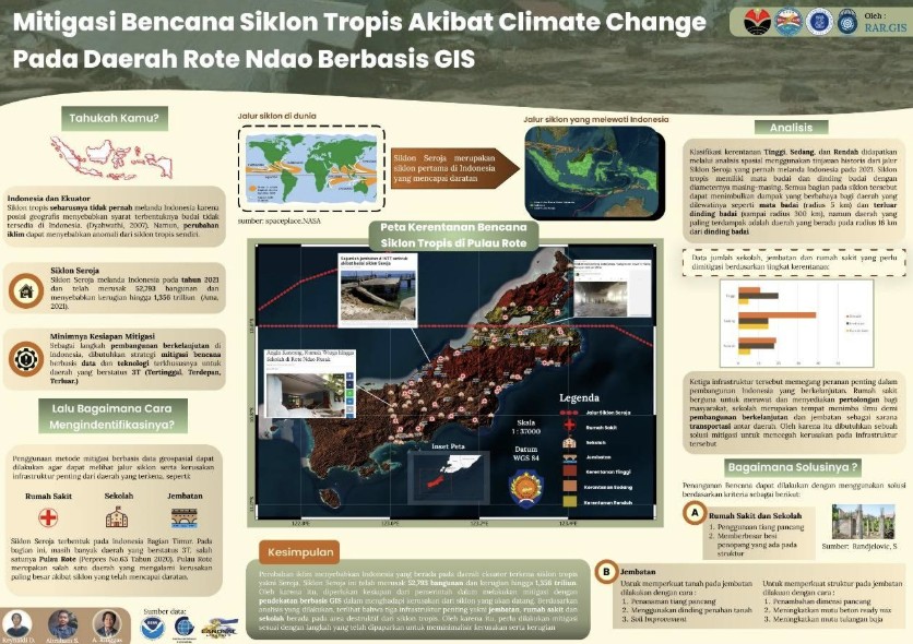
Infographic made by ITB’s RAR.GIS Team titled “Disaster Mitigation of Tropical Cyclones Due to Climate Change in the Rote Ndao Area Based on GIS”. (Doc. ITB’s RAR.GIS Team)
The RAR.GIS team utilized Geographic Information System (GIS) technology to analyze storm paths and identify vulnerable vital infrastructure such as hospitals, schools, and bridges. They then classified the vulnerability levels in Rote Island into three categories, which are high, medium, and low, which are presented in the form of an interactive spatial map. This data-driven approach enabled them to develop precise and resource-efficient mitigation strategies.
With their diverse academic backgrounds, the RAR.GIS team was able to analyze issues thoroughly and design a comprehensive solution. The panelists viewed their initiative as a concrete answer to the challenges of climate change and highly relevant to the competition’s sub-theme, “Climate Change and Disaster Mitigation”.
One of the key moments of their success was during the presentation session. Abraham opened with a captivating “hook” technique that grabbed the judges’ attention from the start.
“We also maintained strong communication within the team, explaining our respective fields of knowledge to each other so the solution would be cohesive from multiple perspectives,” Andrew added.
Although they were not accompanied by a supervising lecturer, they actively had discussions with Meteorology and Civil Engineering students to broaden their understanding of the proposed solution.
In the presentation, they offered concrete strategies, such as installing piles on important buildings, improving the foundation quality of bridges in high-risk zones, and using retaining walls.
As a closing remark, Andrew delivered an inspiring message to fellow students to not be afraid to try new things.
“Just try diving into various types of competitions. You don’t have to overthink it when forming a team, just look around you. Interdisciplinary collaboration is key. The best innovation stems from casual discussions filled with ideas,” stated Andrew.
The success of the RAR.GIS teamproves that interdisciplinary collaboration, the utilization of spatial technology, and an adventurous spirit can bring concrete solutions to Indonesia’s future challenges.
Reporter : Mely Anggrini (Meteorology, 2022)
Translator : Nadya Fini Nabila (Management, 2023)
.jpg)
.jpg)
.jpg)
.jpg)
.jpg)