Due to Land Subsidence, Will Jakarta Be Submerged or Inundated?
By Adi Permana
Editor Adi Permana

BANDUNG, itb.ac.id-- Students from Geodesy and Geomatics Engineering ITB organized a webinar in which they discussed the possibility of Jakarta sinking in the next years. The webinar was titled Geodesink 2021: Our Sinking Capital from a Geodesy Perspective and was streamed live on the Geodesink Youtube channel, Tuesday (14/9/2021).
Dr. Heri Andreas, S.T., M.T., lecturer at the ITB Geodesy and Geomatics Engineering Study Program, and Dr. Agustan, S.T., M.Sc., Director of the BPPT Regional Resource Development Technology Center, spoke at this event. Zachary Adam Hidayat served as MC and Gathan Rasendriya Kumar served as moderator for the event.
Dr. Agustan, the first speaker, began his presentation by quoting a passage from Joe Biden's speech in which he predicted that Jakarta would submerge in ten years. As scientists, he believes that we must be critical, question, explore, and prove this proposition for ourselves.
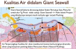
The main issue in Jakarta, according to Dr. Agustan, is flooding. This is due to a variety of factors, including land subsidence and sea level rise. Several research employing satellites, such as altimetry, helped to identify this cause. In 2010, BPPT and Geodesy ITB worked together to process altimetry data. As a result, it was discovered that there is a phenomena known as sea level rise.
Dr. Agustan also revealed that InSAR (Interferometric Synthetic Aperture Radar) technology was employed to observe land subsidence. This observation was carried out between 2014 and 2020, and it can be seen that there are variances in the findings of observations that show land subsidence every year. At the end of his presentation, he stated that Jakarta would be inundated rather than sink.
The presentation by Dr. Harry Andreas followed the next event. He began his presentation by confirming what Dr. Agustin had just said, that Jakarta will not submerge. "The news that Jakarta is sinking is just clickbait to raise public awareness," a lecturer from the Geodesy Research Group group explained. He also stated that the public's response to this issue must be essential.
He explained that soil subsidence has been occurring in Jakarta since 1997. This conclusion was reached by employing LIDAR (Light Detection and Ranging) technology to model land subsidence. In addition to LIDAR, data from 2007 to 2018 is supplied by the InSAR fleet, and it can be seen that there is land subsidence in various regions. "Some achieve 20 cm per year," he said. However, the rate of ground subsidence has decreased in recent years.
He added that by incorporating sea level rise and land subsidence into the topography, we can determine which locations are likely to be below sea level per unit time. A subsidence scenario was created in 2012, and it was discovered that Jakarta had a 31% chance of sinking. After the scenario is modified, there is a potential reduction of up to 28%. "It does appear reduced, but the potential remains," he said. Of course, because this topography is dynamic, it will be updated in the future.
According to the most recent updated model data, 9000 hectares of land are already below sea level, although in the field it remains dry due to the development of sea dikes and river embankments.
This year, 14 percent of Jakarta's land area is already under water, with the figure anticipated to rise to 28 percent by 2050. Some areas, such as Muara Baru, have dropped by as much as one meter. This must be taken into account because if it is not, it will continue to increase. "If our efforts are not perfect, the decline will reach 4 meters by 2050," he predicted.
Dr. Andreas and his colleagues developed a hypothetical model that, if only affected by sea level rise, would result in the inundation and submergence of only 292 hectares of land. However, when the effect of ground subsidence is taken into account, the area increases to 9000 hectares. In addition to these two factors, climate change on the coast has the potential to submerge 16000 hectares of land.
"To prevent or delay the sinking of Jakarta, it is vital to conduct monitoring and early warning, identify causal causes, and map disaster risk with more accuracy," he explained. This can be accomplished by building embankments, installing pumps, and searching for alternate groundwater sources, as groundwater extraction promotes land subsidence.
Geodesy and geomatics, according to Dr. Andreas, are in charge of analyzing disaster risk. He also urged the public not to be concerned or paranoid. "Jakarta sinking is clickbait in media parlance; there's no need to panic; Jakarta has the capacity to sink, but it won't sink," he told all those present.
Reporter: Kevin Agriva Ginting (Geodesy and Geomatics Engineering, 2020)
Translator: Sekar Dianwidi Bisowarno (Bioengineering, 2019)
.jpg)
.jpg)
.jpeg)
.jpg)
.jpg)